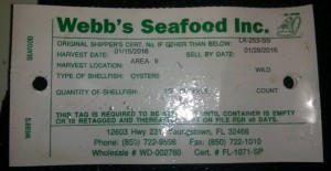
One of many fascinating oyster-facts I learned on a visit to Bon Secour Fisheries is that every oyster you purchase from a restaurant or market is associated with a tag. If you know how to read an oyster tag, you know who packed and shipped it, its date of harvest and even the oyster harvest location. The U.S. Food and Drug Administration requires producers to include tags with this information for all oysters. Restaurants and other outlets are required to keep the tags on file for 90 days, allowing the oysters to be tracked back to their supplier and source waters if needed.
If you want to know how fresh your oysters are, or you’re curious about where your gulf oysters were dredged, or just want to confirm that the raw bar is really serving local oysters, ask to see the label.
How to Read an Oyster Tag

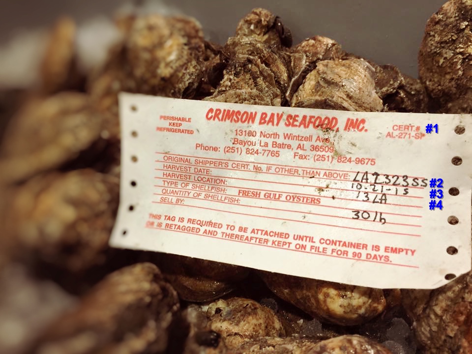
I’ve added blue numbers to the oyster tag photo above to indicate four key pieces of information.
#1 and #2 indicate processors and suppliers that are certified by the U.S. Food and Drug Administration and included on the Interstate Certified Shellfish Shippers List. “AL-271-SP” (#1) is the certification number for Crimson Bay Seafood. The “SP” at the end of the number shows that Crimson Bay Seafood is a “Shucker-Packer,” certified to shuck and pack oysters (and other shellfish).
The original shipper’s certification number “LA 2323 SS” (#2), indicates that the oysters were originally shipped from P.S. Fisheries in Empire, Louisiana. The “SS” at the end of their number indicates that P.S. Fisheries is a “Shellstock Shipper,” certified to grow, harvest, buy, or repack and sell shellfish.
#3 is the harvest date for the oysters and what most people look for on the tags. These were dredged, raked, tonged, or removed from their baskets for sale on 10-21-15. Avoid oysters harvested more than 14 days ago. Most people want their oysters to be out of the water no more than five or six days. The fresher they are the better.
#4 is “Harvest Location,” my favorite bit of information about the oysters. This is the key to finding where your oysters spent their watery youth and gathered all of their briny, creamy goodness. While the oysters in the photo above were packaged in Bayou La Batre, Alabama, “Harvest Location: 13LA” indicates they were harvested in Louisiana Area 13 (which includes Grand Isle).
Oyster Harvest Location Maps
Following are the maps for oyster-producing states. Note that each state has its own approach for mapping and describing harvest areas. Some are easy to read and clearly understood. Others are as muddy as a Low Country oyster bed.
Gulf Coast
- Alabama Shellfish Harvest Area Designations Map
- Florida Shellfish Harvesting Area Maps offers a full map of the state’s harvesting areas. You can also start with a list of area numbers and drill down to detailed area maps from Florida Shellfish Harvesting Area Information.
- Louisiana Shellfish Harvest Areas PDF map. You can also download the Louisiana Oyster Commercial Rules and Regulations that includes the map.
- Mississippi Oyster Harvest Maps. Mississippi oyster harvest areas are also mapped in the PDF Oystermen’s Guide to Mississippi Gulf Coast Oyster Reefs from their Oyster Stewardship Program.
- Texas Shellfish Harvesting Area and Maps
East Coast
- Connecticut Shellfish Area Classifications & Maps
- Delaware Division of Watershed Stewardship Shellfish Growing Waters
- Florida Shellfish Harvesting Area Maps offers a full map of the state’s harvesting areas. You can also start with a list of area numbers and drill down to detailed area maps from Florida Shellfish Harvesting Area Information.
- Georgia’s coastal counties each have a brochure with a detailed map of public recreational shellfish harvest areas. See “Shellfish Maps” on this page.
- Maryland offers detailed descriptions of their harvest areas in MDE’s Shellfish Growing Water Classifications, and an incredibly detailed interactive Shellfish Harvesting and Closure Area Map.
- Maine Shellfish Growing Area Reports
- Massachusetts Designated Shellfish Growing Areas
- New Jersey 2015 Shellfish Growing Water Classification Charts
- New York State Shellfish Harvest Areas Map
- North Carolina Shellfish Harvesting Area Maps
- Rhode Island Shellfish Harvest Area Tagging Map
- South Carolina Shellfish Management Areas
West Coast
- Oregon Department of Agriculture Shellfish Program Classified Commercial Shellfish Growing Area
- Washington Commercial and Recreational Shellfish Growing Areas shows the state’s numbered areas. You can also find updated and detailed information on commercial shellfish classifications on the Washington State Department of Health interactive map.
More Map Links Coming Soon:
- California
- New Hampshire
- Virginia

More About Oyster Tagging and Tracking
- “Oyster Fraud: The Restaurant Industry’s Dirty Little Secret” Rachel Tepper Paley, Yahoo Food
- “Your Oysters Are Impostors—Expensive, Slurpable Frauds” Clare Leschin-Hoar, Takepart
- “How to Buy Oysters Like a Pro” Janet Rausa Fuller, Epicurious
- “Washington Oyster Poaching Case Reveals Shellfish Safety Gaps” Austin Jenkins, NPR
Get hundreds of the best oyster recipes from your favorite magazines, cookbooks, chefs and food blogs, every day, 365 days a year! You can find them all, fried, smoked, baked, grilled, sandwiched, stewed, even pickled, right here on Oyster Obsession.